Track All of Your Outdoor Activities in One App
GPS Tracks is an exceptional app for offline hiking, running, walking, cycling, and any other route tracking activity. It is a perfect companion for traveling, hunting, fishing, and other navigational activities where you need to store specific locations. It is a must have for photographers who need to track location data for their pictures.


App Features
GPS Tracks makes navigating and tracking your outdoor activities very simple. It will keep track of your routes and allow you to easily navigate to waypoints. You can store maps for offline use as well as add map overlays.

Track
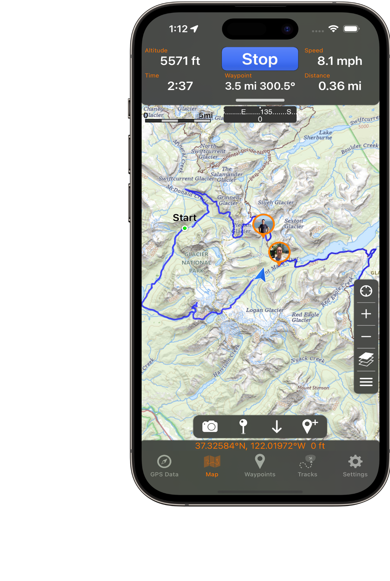
Record the breadcrumb route of your activities. Add them back to the main map to follow along or use as a guide.

Waypoints
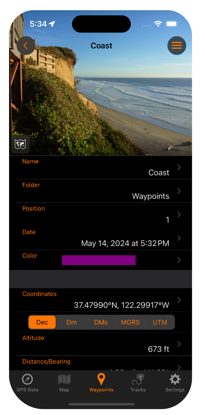
Add waypoints by dropping a pin, entering coordinates, averaging current location, with angle and distance, or by taking a picture. Easily navigate to waypoints with the waypoint guide on the compass.

Live Activities & Widgets
Live Activity for tracking and waypoint navigation. Widgets for Distance Today and Add Waypoint.

Connect
Use iCloud to sync across all your devices. Share your location. Import tracks or waypoints in a GPX, KML, KMZ, BIN, CSV, or NMEA format
Pro & Premium Features
Take GPS Tracks to the next level with the Pro and Premium subscription.
Offline maps
Use Street, Terrain, Satellite, USGS, NOAA nautical charts, FAA charts, and many other alternate map sources to save for offline use

Map Overlays
Add map overlays of local trails or area boundaries from images, files, or directly from your camera

Range Finder
Find distance from any point on the map quickly and accurately.

Print maps
Create a a beautifully crafted map of multiple tracks and waypoints to share as a file or print out a hardcopy.

GPS Tracks Live
Share your track securely in real time with your friends. GPS Tracks account required.

Track Sharing
Share saved tracks securely online with your friends. GPS Tracks account required.

Measure
Measure area, distance, or along a track on the map.

Export Files
Export tracks or waypoints in a GPX, KML, KMZ, BIN, CSV, or NMEA format.

Elevation Profiles
Update the elevation for tracks or waypoints.

Weather
View current weather and the weather at each waypoint.
How Does It Work?


Step 1. Record your Track
Hit the Start button to begin recording your track. Easily add waypoints to the map to save with your track.
Step 2. Add Waypoints
Add waypoints with pictures to save points of interest. Waypoints can be saved to a folder or with a track.
Step 3. Offline Maps
With GPS Tracks Pro subscription, you can save maps for offline use to allow you to go completely off the grid. Choose from Satellite, Street, Terrain, Topo, Thunderforest, TomTom, AccuTerra, USGS, NOAA, FAA, ESRI, Open Street Maps
Step 4. Download Maps for Tracks
Download maps for any track to use while offline with the GPS Tracks Premium subscription.
Step 5. Add Map Overlays
Add map overlays on any map style. Great for when you are hiking or in a park and need to add the local trail map. You can add an overlay from a pdf, an image, or right from your camera.
Step 6. GPS Tracks Live
Follow your friends in real time on the map. You can share your track while recording or continuously. With the Premium subscription you can share your track with anyone.
Step 7. Follow Tracks
Add recorded tracks and/or imported routes to the map to follow along your track. Tracks can be imported/exported with GPX, KML, or CSV format.
Step 8. Navigate Waypoints
Easily sort and navigate to your waypoints. Once the waypoint is reached, you can move on to the next waypoint.
Step 9. Range Finder
Easily find the distance and elevation angle & difference between any two points.
Step 10. View Track Details
View speed, altitude, and heart rate vs time or distance, view waypoints saved with the track, and view detailed statistics of the track.


Use your watch to create tracks and waypoints
- Record your activity
- Add waypoints
- Mirror watch activity to phone


View tracks and waypoints on your Mac
View and edit tracks. Create printed maps.
View and edit waypoints.
Customer are Loving GPS Tracks
Fantastic - This is by far the best GPS app I have found. And I have tried lots for personal use and for my work as a wildlife biologist. Using this app, I no longer carry a stand alone GPS unit. Highly recommended.
Myhippocket
App Store CustomerBest Map App Ever - I have used this time and time again in the oilfield and have never been disappointed. Once you get the hang of it this quickly becomes your go to getting some place. I have used it overseas as well Japan, and Turkey. I can leave a blue line and always find my way back. Even when you are out of service this app has saved my life more times then I can count. One amazing feature is the ability to save pins tracks and other information I often become the navigator at work.
BalthazarWoll
App Store CustomerIf You Like Google Maps - You’ll love this app. Before getting this app I often used google maps or Apple Maps… long story short, if you look at various Satellite Imagery or maps often, and want to trace your steps via an assortment of map types, this is the app for you. The app provides lots of optionality and usefulness for me. Layout and ease of use is pretty darn good imo. Solid, for what it’s worth, I love this app and highly recommend it.
Tarfet66
App Store CustomerGPS Tracks - Used for documentation for SAR K-9 tracking/trailing and human remains searches with law enforcement. Easily shared. Has a space for notes. Much better than the Mantrailing app. Has been a good replacement for Motion X GPS that it is no longer supported. Easy access to tech support.
K-9 SAR
App Store CustomerGreat Customer Service and Great Product - I’ve used this app to log sampling site locations for geology field work. It’s simple and intuitive. I came here specifically to praise their customer service. I had a problem where I thought I’d lost data when an expired credit card turned into a lapsed subscription, and sent an email to the app support. They responded very quickly and let me know that I could still access my waypoints just by signing in to iCloud — super prompt, professional, and kind!! I will definitely keep using this app for all my field work GPS needs.
RitaP01234
App Store CustomerAny questions?
Check out the FAQs
Still have unanswered questions and need to get in touch?
Still have questions?
Email SupportThe GPS signal is independent of the cellular signal. The app will record your route with out a cellular signal, but you will not be able to use the map unless you have downloaded map tiles prior to losing internet service. You can alos create waypoints without cell service or internet.
Yes, GPS Tracks will work with any third party bluetooth GPS receiver connected to your iphone.
If the app will not open, then try opening the iPhone or iPad Settings app for the device. Then scroll down to the Installed Apps section and select GPS Tracks. Then disable the Auto Restore Map Data option and open the app. When you open it, there may be a prompt to restore the data on the map, select No to not restore the data. This will not delete any data, except for a track that was being recorded, the rest of the data on the map will be saved in the Waypoints or Tracks tabs.
If one or more tracks did not sync to another device running GPS Tracks, then you can open the device with the original track and select it to view the details. Then from the menu choose the Sync with iCloud option and choose the Update Server from the prompt. This will sync the track to the server and it should update all of your devices automatically.
If you have already purchased the subscription, then you can tap on the subscription link at the top of the Settings tab. Then scroll down to the bottom and tap on the Restore button. This will refresh your subscription in the app.
See the Download Maps section
The track detail view graph can be swiped up to reveal the track details where you can edit the track, customize the view, or view the detailed stats for the track.
You can navigate to a waypoint by adding it to the main map and then tapping on the pin to view the details. Then tap on the Navigate button at the bottom. The distance and bearing information will now appear in the GPS Data tab. The bearing will also be indicated by the orange arrow on the compass.
GPS Tracks uses CloudKit to sync the data across devices. This data is only visible from GPS Tracks and is not stored in iCloud Drive.