Version 1.0.2
Released on March 13th, 2012- New Full iOS 5.1 compatibility
- Fix Push notifications update & fixes
- New Added dashboard refresh button
- fix Various UI enhancements
I am an independent IOS app developer. If you have suggestions or change requests, or maybe even a bug report, please email me and I will make sure it gets fixed.
GPS Tracks is one of the best apps for editing and creating tracks on your iPhone, iPad, or Mac. Sync all of your saved tracks from GPS Tracks over iCloud for editing and reviewing.
Do you want to track your outdoor activities? Do you want to store your favorite destinations? Do you need to reference locations in MGRS or UTM notations as well as the decimal notation? Would you like to share your location or any of your waypoint locations via text message or email?
GPS Tracks is one of the premier navigation / activity tracking apps in the App Store. It is the perfect companion for any outdoorsman looking to navigate to waypoints or anyone wanting to track their route. It has a playback feature as well as detailed statistics on your track.
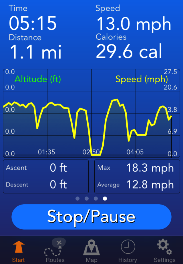
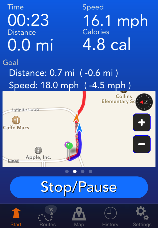
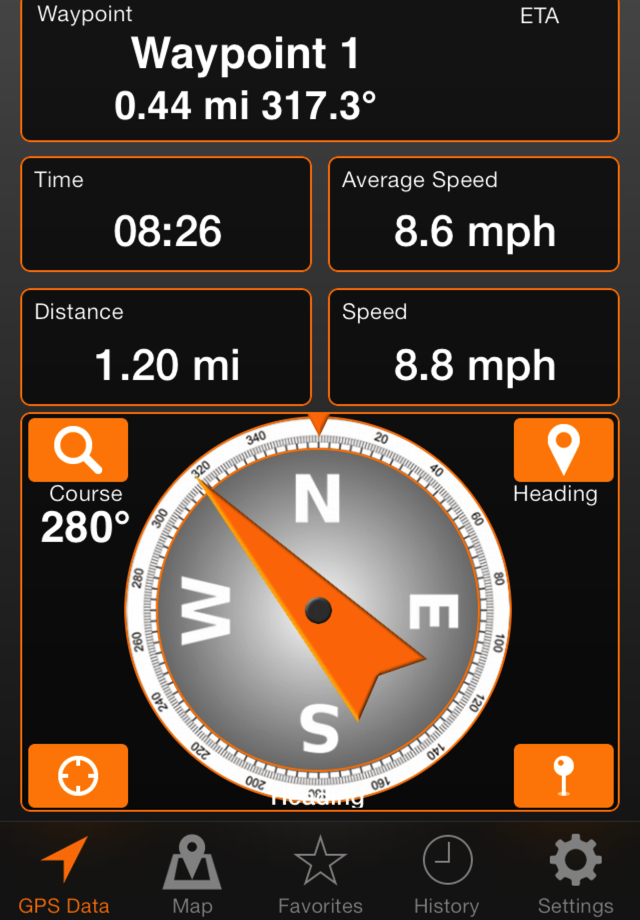
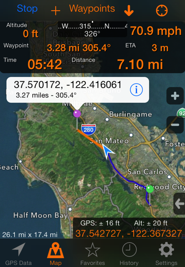
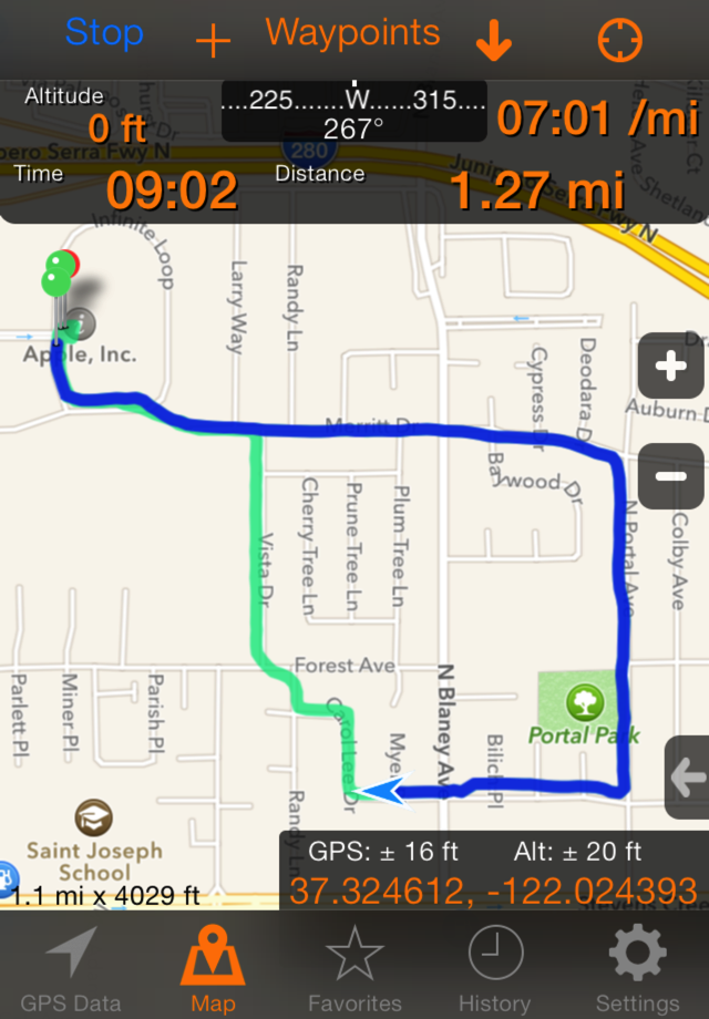
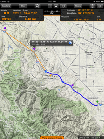
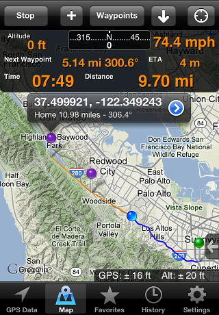
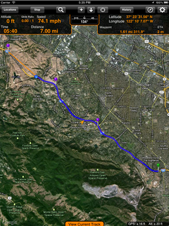
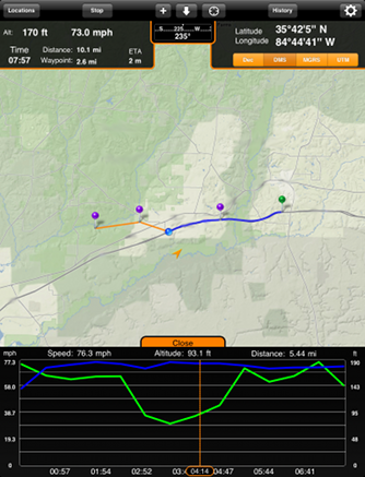
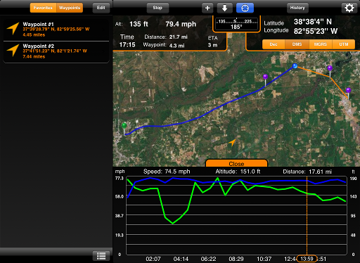
It will display your current coordinates in one of four different coordinate systems (Decimal, DMS, MGRS, UTM). It will track your speed or pace depending on how fast you are traveling. It will track your current course, give you elapsed time, distance traveled, distance to waypoint, and estimated time of arrival to your next waypoint. It also gives you your current heading and has the option to have course-up or direction-up maps.
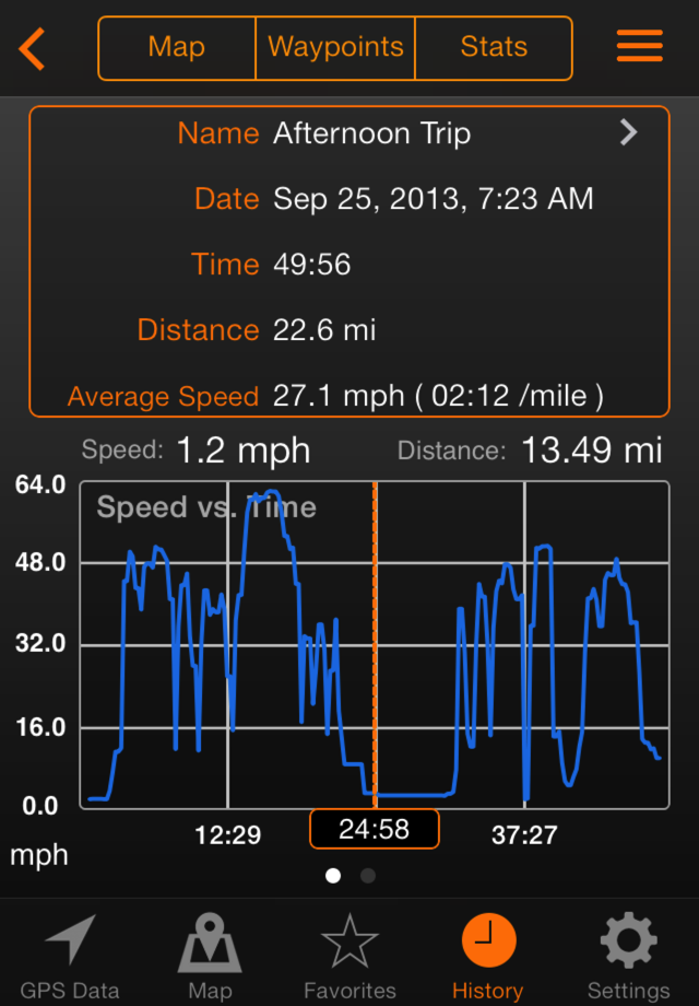
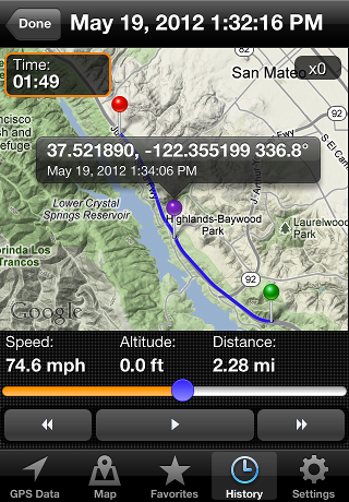
GPS Tracks will track and record your position and allow you to save the route to the History tab. A detailed view of the track as well as a playback can be viewed.
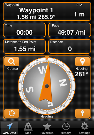
GPS Tracks has a built in compass to guide you to your next waypoint. It will also give you distance bearing and estimate time of arrival to the next waypoint.
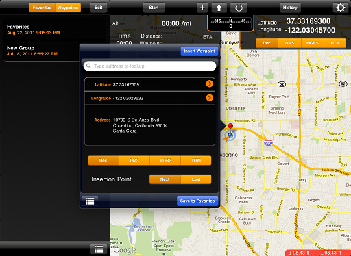
You can store any location to the device for quick reference later. A location can be saved from any waypoint added tot he screen or you can save your current location directly in the Favorites tab.
You can export and import your saved locations and tracks. GPS Tracks can handle GPX, KML, KMZ, CSV, and its own XML format. You can also send your current location to others via a text message.
A compass is displayed with the current heading or course along with the bearing to the next waypoint to easily navigate your course.
Please look over the FAQ below or take a look at the Users Manual. If you still have a question or want to submit a feature request please send an email to support@dmsoftwaresolutions.com
Easily navigate to waypoints using the compass view. The compass will display an orange arrow to point in the direction of the current waypoint. The distance, bearing and estimated time of arrival is also displayed at the top of the view. Tap the waypoint view to check-in or remove the waypoint and proceed to the next waypoint.
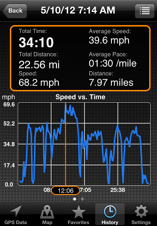
You can view your recorded tracks on the map and also view a speed and altitude versus time plot. Each track can be played back at varying speeds. The recorded tracks can be exported to GPX, KML, or CSV format or added to the main map.
You can easily enter waypoints with either the address, coordinates (decimal, DMS, MGRS, UTM), or by dropping a pin on the map. You can also convert coordinates on the fly as you enter them. You can edit the coordinates of your waypoints as well as the order in which they occur. GPS Tracks uses WGS84 datum. You can store your favorite locations along with an optional picture.
To access the files that are exported to the device in the app, you must plug your device into the computer and open iTunes. Then select your device on the left side menu. Select "Apps" from the top menu that is now present. Scroll down to the "File Sharing" section and select "GPS Tracks" under the "Apps" section. This should bring up a list of all the files on your device, which you can add, delete, or save them to and from your computer.
The GPS signal is independent of the cellular signal. The app will record your route with out a cellular signal, but you will not be able to use the map unless you open the app while connect to the internet to cache some of the map tiles. Note that when the map has no map tiles cached then you cannot add waypoints to it either.
Yes, but requires the GPS Tracks Pro In-App Purchase. GPS Tracks Pro is an auto-renewing subscription that allows the user to download unlimited map tiles for offline use.
Yes, it will use the XGPS150 if it connected to your device via bluetooth.
It is strongly recommended that you cloase the app completely during an update, otherwise this can cause the app not to work anymore. If you find yourself in this situation then please email the developer.
Do you want to track your outdoor activities? Do you want to store your favorite destinations? Do you need to reference locations in MGRS or UTM notations as well as the decimal notation? Would you like to share your location or any of your waypoint locations via text message or email?
GPS Tracks is one of the premier navigation / activity tracking apps in the App Store. It is the perfect companion for any outdoorsman looking to navigate to waypoints or anyone wanting to track their route. It has a playback feature as well as detailed statistics on your track.
It will display your current coordinates in one of four different coordinate systems (Decimal, DMS, MGRS, UTM). It will track your speed or pace depending on how fast you are traveling. It will track your current course, give you elapsed time, distance traveled, distance to waypoint, and estimated time of arrival to your next waypoint. It also gives you your current heading and has the option to have course-up or direction-up maps.
GPS Tracks will track and record your position and allow you to save the route to the History tab. A detailed view of the track as well as a playback can be viewed.
GPS Tracks has a built in compass to guide you to your next waypoint. It will also give you distance bearing and estimate time of arrival to the next waypoint.
You can store any location to the device for quick reference later. A location can be saved from any waypoint added tot he screen or you can save your current location directly in the Favorites tab.
You can export and import your saved locations and tracks. GPS Tracks can handle GPX, KML, KMZ, CSV, and its own XML format. You can also send your current location to others via a text message.
A compass is displayed with the current heading or course along with the bearing to the next waypoint to easily navigate your course.
Please look over the FAQ below or take a look at the Users Manual. If you still have a question or want to submit a feature request please send an email to support@dmsoftwaresolutions.com
Easily navigate to waypoints using the compass view. The compass will display an orange arrow to point in the direction of the current waypoint. The distance, bearing and estimated time of arrival is also displayed at the top of the view. Tap the waypoint view to check-in or remove the waypoint and proceed to the next waypoint.
You can view your recorded tracks on the map and also view a speed and altitude versus time plot. Each track can be played back at varying speeds. The recorded tracks can be exported to GPX, KML, or CSV format or added to the main map.
You can easily enter waypoints with either the address, coordinates (decimal, DMS, MGRS, UTM), or by dropping a pin on the map. You can also convert coordinates on the fly as you enter them. You can edit the coordinates of your waypoints as well as the order in which they occur. GPS Tracks uses WGS84 datum. You can store your favorite locations along with an optional picture.
To access the files that are exported to the device in the app, you must plug your device into the computer and open iTunes. Then select your device on the left side menu. Select "Apps" from the top menu that is now present. Scroll down to the "File Sharing" section and select "GPS Tracks" under the "Apps" section. This should bring up a list of all the files on your device, which you can add, delete, or save them to and from your computer.
The GPS signal is independent of the cellular signal. The app will record your route with out a cellular signal, but you will not be able to use the map unless you open the app while connect to the internet to cache some of the map tiles. Note that when the map has no map tiles cached then you cannot add waypoints to it either.
The license agreement prohibits us from manually storing the map tiles for offline use.
The license agreement prohibits us from manually storing the map tiles for offline use.
Yes, it will use the XGPS150 if it connected to your device via bluetooth.
It is strongly recommended that you cloase the app completely during an update, otherwise this can cause the app not to work anymore. If you find yourself in this situation then please email the developer.
Track your runs, walks, biking activities and any other outdoor sport using your GPS!
No account or login required!
Fitness Tracks will record your workout and display detailed stats during and after your activity.
Easily create routes to follow during your workout. Routes can be created by dropping waypoints on the map or by drawing by hand. The routes can freeform or follow the roads.
Tracks and routes can be exported to share as GPX or KML files to Dropbox or iTunes. Data can be synced with iCloud.
Please take a look at the Users Manual. If you still have a question or want to submit a feature request please send an email to support@dmsoftwaresolutions.com


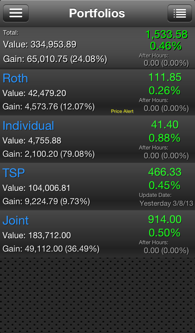
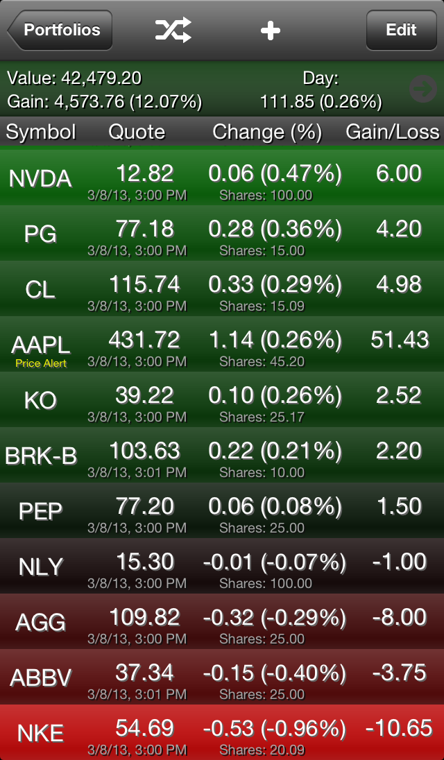
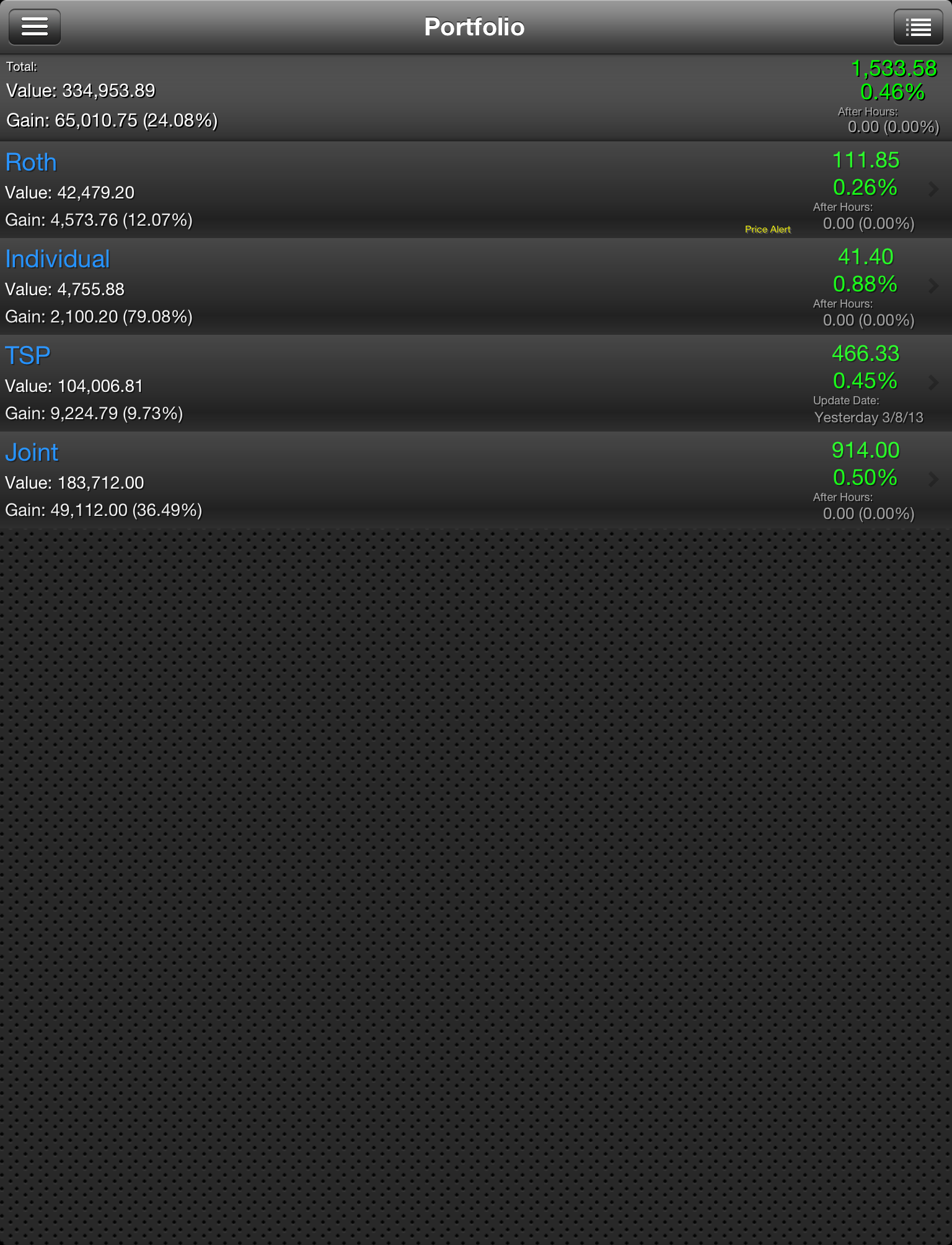
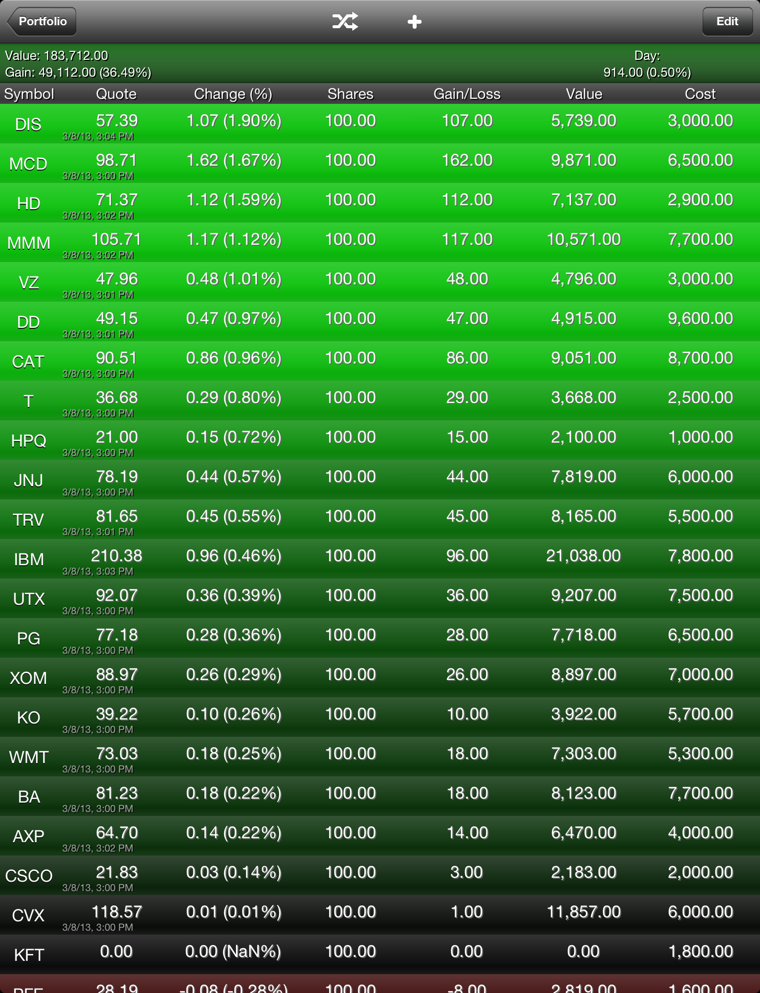
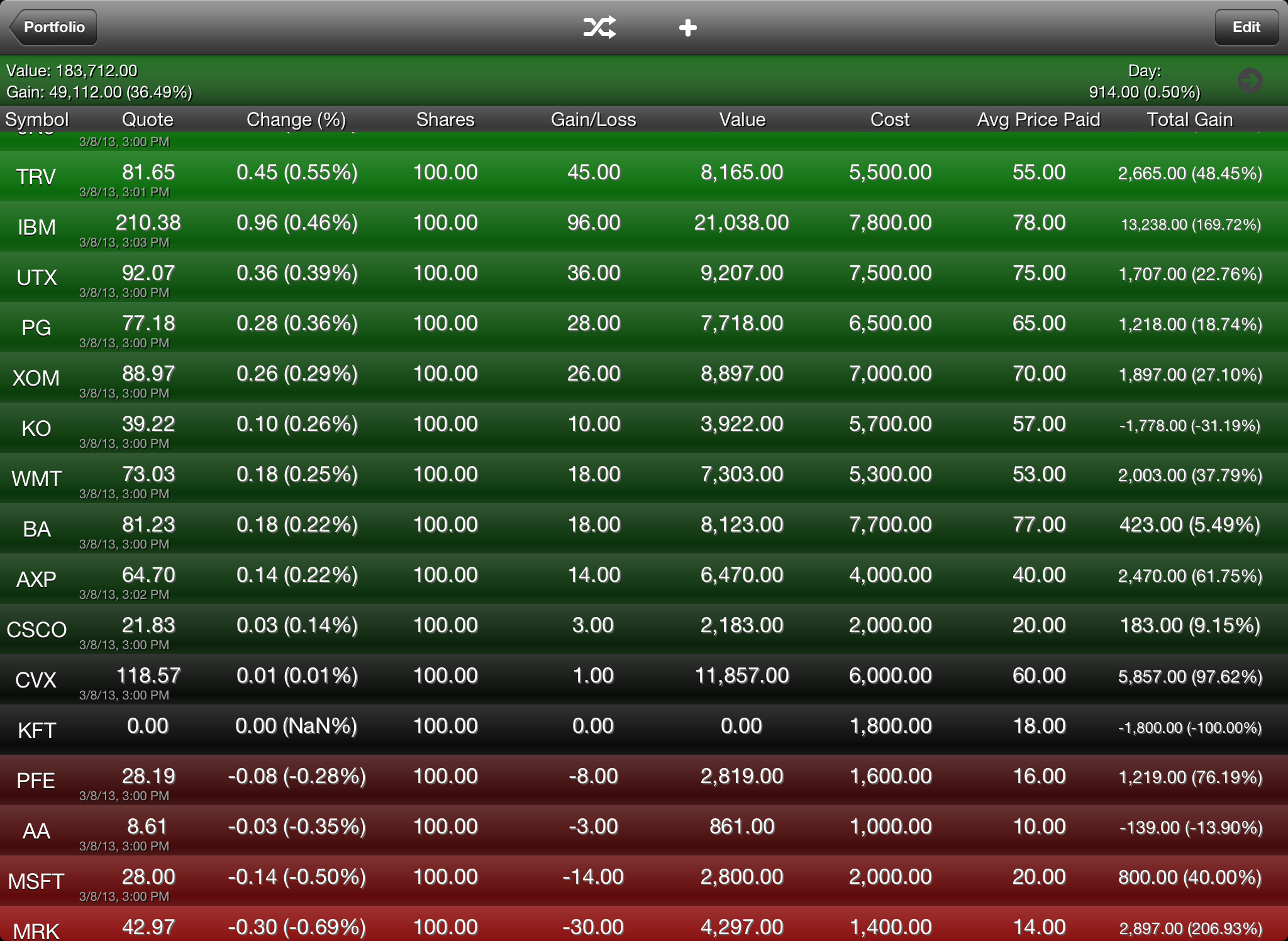
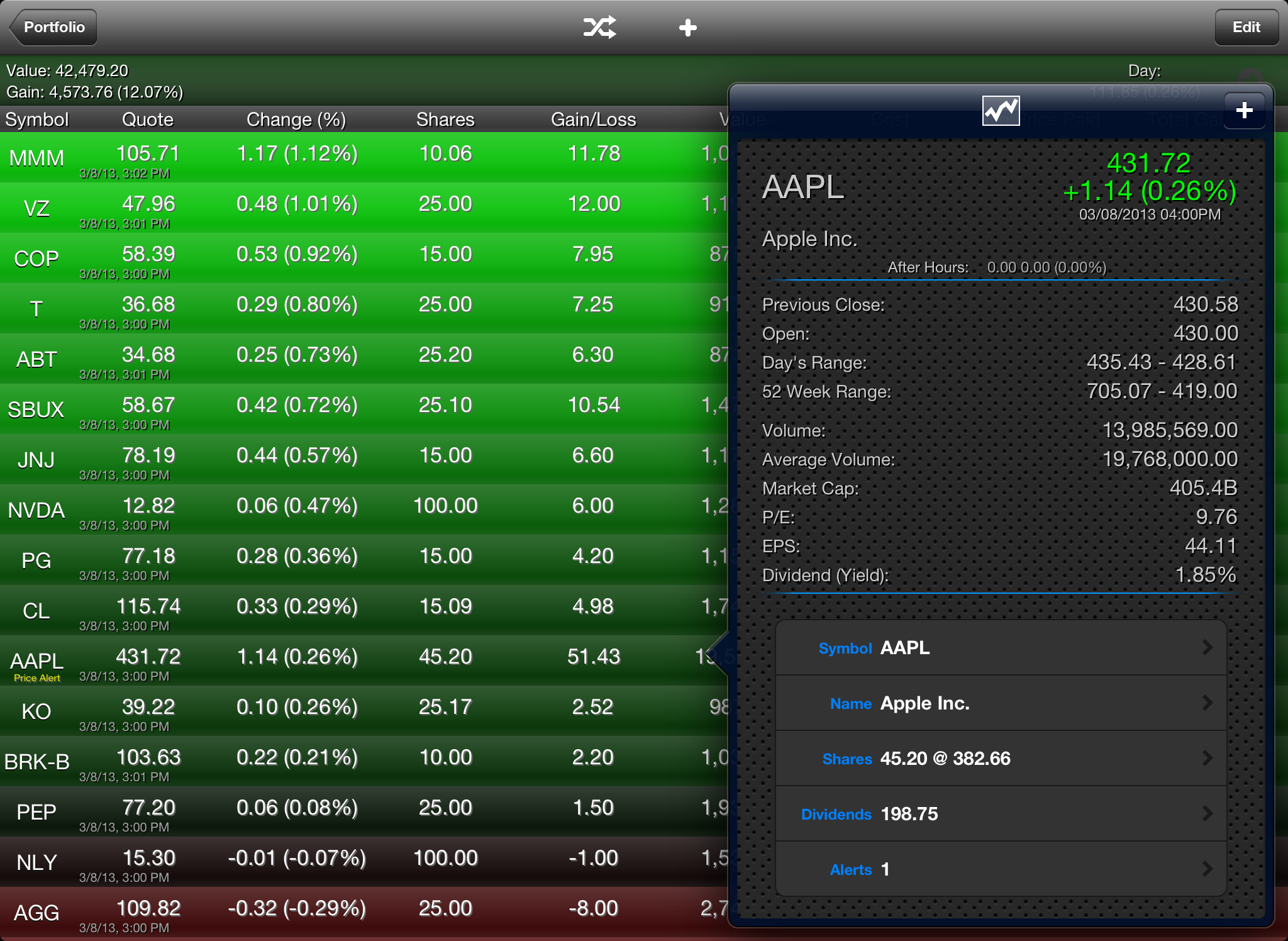
If you are someone who needs to track your portfolio closely, then this is the app for you. Easily track your portfolios throughout the day with Stock Portfolio. This app will let you create multiple portfolios. Adding stock positions is very easy, but you can also import a CSV file. You can even add or import Thrift Savings Plan (TSP) funds to your portfolio.
You can add buy and sell position data for each portfolio. You can also add multiple lots and dividends to each stock position. It also has the ability to calculate reinvested dividends.
Add multiple watch lists and set price alerts for each stock. Price alerts are displayed in the app, it does not support push notifications.
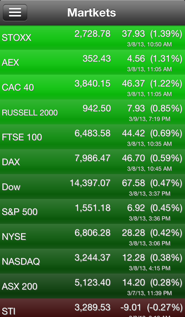
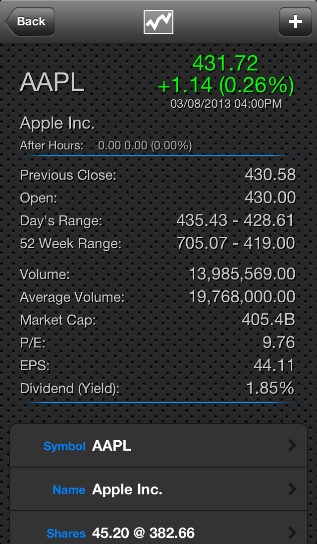
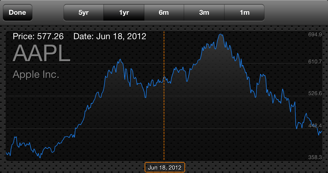
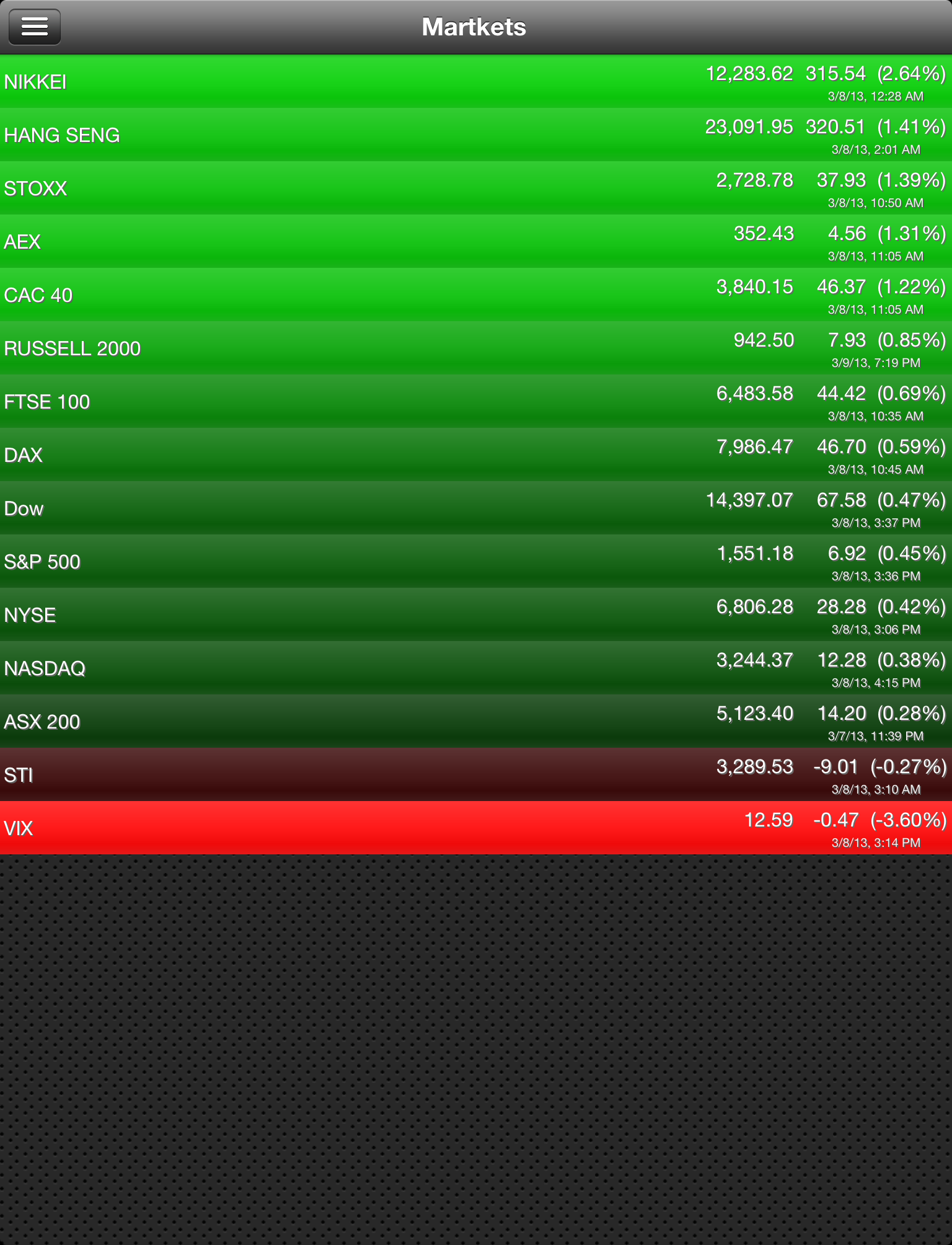
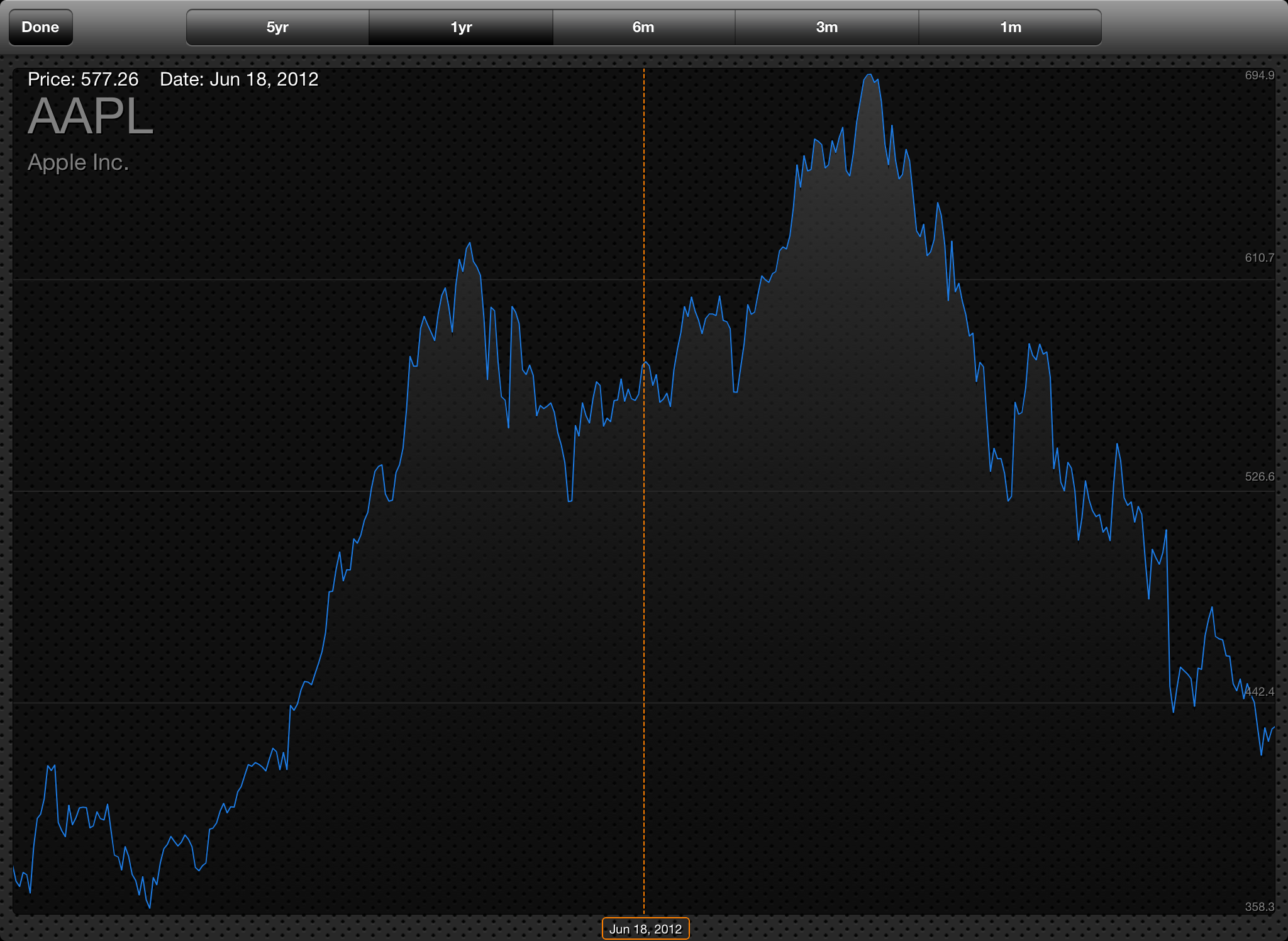
View the stock chart for each stock in five different time intervals - 5 year, 1 year, 6 months, 3 months, 1 months.
Real-time quotes with the option to get after hours quotes. After-Hour quotes are only available during after hours trading. Quotes are pulled form Google Finance and Yahoo Finance. The stock symbol must be present on at least one of these services to retrieve quotes.
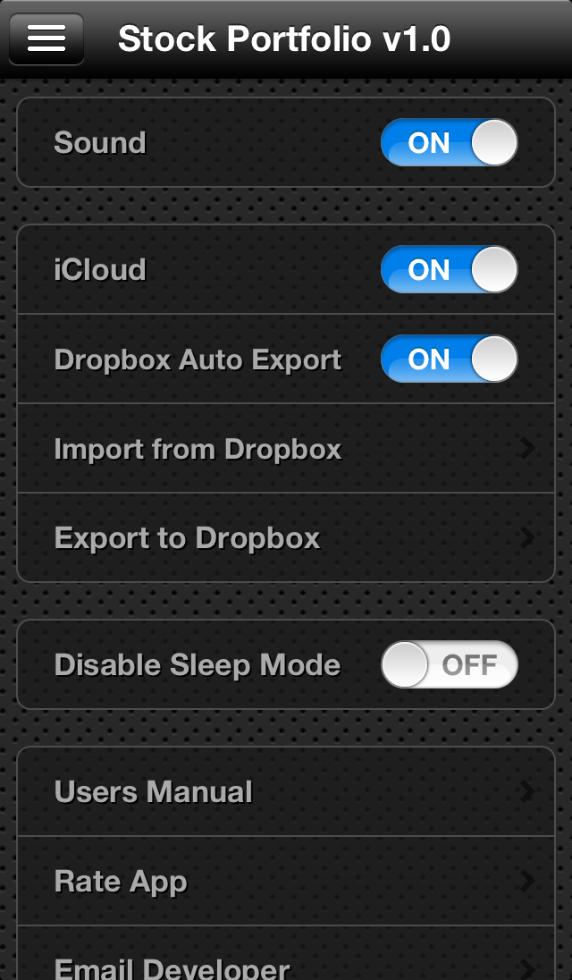
You can enable iCloud support for the app to seamlessly sync all your devices with the most up to date portfolio positions. You must be logged into an iCloud account in the device settings to enable this feature.
Please look over the FAQ below or take a look at the Users Manual. If you still have a question or want to submit a feature request please send an email to support@dmsoftwaresolutions.com
Portfolio, Watch List, Cash, Symbol, Name, Date, Shares, Price, Dividend, Commission
In order for the price to get updated the stock symbol must reside in either Yahoo Finance or Google Finance.
This app is highly dependent on an internet connection. Sometime the web service times out and no quotes are updated. This can also happen when importing your Google Finance portfolios.
The Stock Portfolio app adds the ability to add multiple lots to each stock position as well as the ability to add dividends to each position. It also has the ability to add watch lists and a separate screen for market indices. It features the ability to get quotes for stocks not in your portfolios or watch lists. It also features charts for each stock.
If you are someone who needs to track your portfolio closely, then this is the app for you. Easily track your portfolios throughout the day with Stock Tracker. This app will let you create multiple portfolios where you can import your portfolios with a CSV file, or manually add your stock purchases. You can even add or import Thrift Savings Plan (TSP) funds to your portfolio.
Import all of you portfolios from a CSV file.
Real-time quotes with the option to get after hours quotes. After-Hour quotes are only available during after hours trading. Quotes are pulled form Google Finance and Yahoo Finance. The stock symbol must be present on at least one of these services to retrieve quotes.
Stock positions are color coded red to green and sorted for either the day gain or the overall gain. A pinch gesture will reveal a more detailed view of the stock positions.
You can enable iCloud support for the app to seamlessly sync all your devices with the most up to date portfolio positions. You must be logged into an iCloud account in the device settings to enable this feature.
Stock Tracker takes full advantage of the touch interface. Pinch the table for detail information. Swipe to go back a page. Pull down on any table to refresh.
Please look over the FAQ's below or take a look at the Users Manual. If you still have a question or want to submit a feature request please send an email to support@dmsoftwaresolutions.com.
In order for the price to get updated the stock symbol must reside in either Yahoo Finance or Google Finance.
This app is highly dependent on an internet connection. Sometime the web service times out and no quotes are updated. This can also happen when importing your Google Finance portfolios.
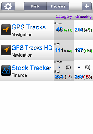
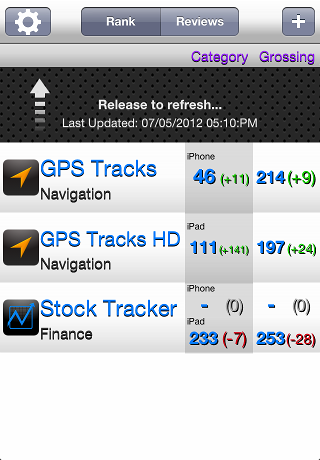
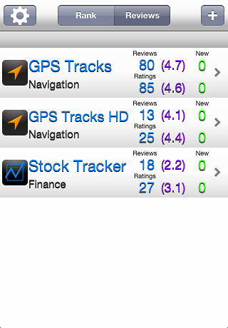
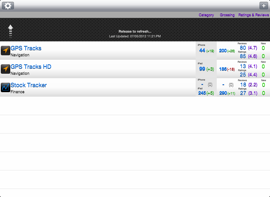
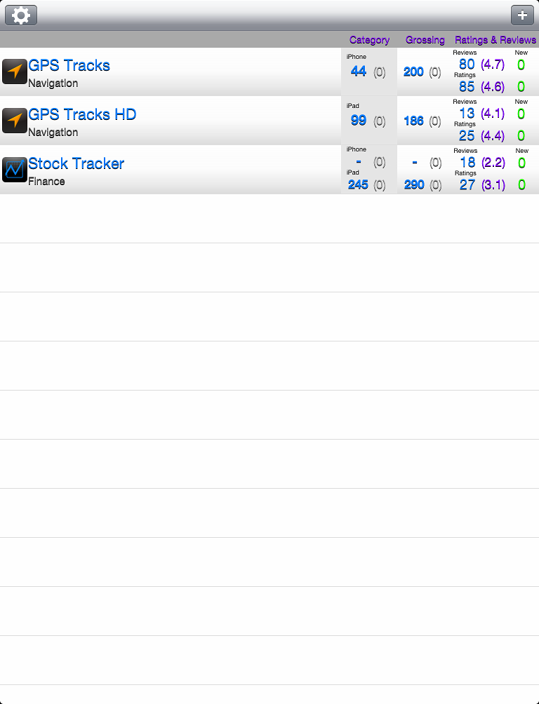
App Rank & Review is a great way for App Store developers to track their own apps.
You can track your current rank in the category or the overall store. Everytime you refresh it will tell you the cahnge in rank as well.
It will keep track of all the reviews worldwide as well as all of the ratings. It will show you new ratings and reviews.


mapPoints is a handy app to store all of your favorite locations.
View your altitude and heading on the map view. Your GPS signal accuracy is also displayed.
You can store your location in one of four ways - use your current location, type in an address, use custom coordinates, or drop a pin on the map.
There is an option to draw lines between the map location displayed on the map. You can draw a line between all of the locations in the order selected including the user location. You can draw a line from the user location to the last location selected. You can draw a line form the user location to the first location selected. And you can draw a line between all of the points excluding the user location. This last option is handy when trying to compute distance on a map. When drawing any lines on the map, the distance is displayed in the lower right corner of the screen.
mapPoints is a simple app to store and quickly access your favorite locations. GPS Tracks is a very robust navigation and tracking app that also store your favorite locations.
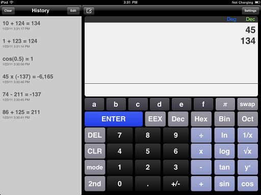
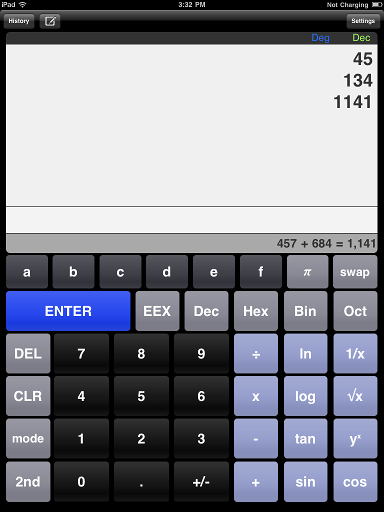
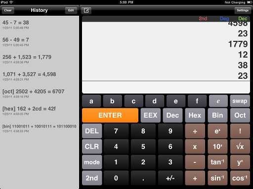
A classic RPN calculator
With RPN you can work faster and preform more calculations with less keystrokes.
All the math operations are on one page along with a scrollable history page.
Features four different number base formats. It will convert and do basic math operations on any of the number bases.
The display has an eight line scrollable stack so you can see all of the past solutions to your calculations. It also features a history tape of all your past calculations.
A classic RPN calculator
With RPN you can work faster and preform more calculations with less keystrokes.
All the math operations are on one page along with a scrollable history page.
Chose the input mode for addition, subtraction, multiplication, and division.
Swipe up to reveal a list of your past math operations.
A classic RPN calculator
With RPN you can work faster and preform more calculations with less keystrokes.
All the math operations are on one page along with a scrollable history page.
Features four different number base formats. It will convert and do basic math operations on any of the number bases.
The display has an eight line scrollable stack so you can see all of the past solutions to your calculations. It also features a history tape of all your past calculations.
A Radar Equation App
Calculate the power received from a transmitter using the radar equation. Inputs are in dB units.
Calculate the power transmitted as seen from the receiver and the ratio between the power transmitted and power received.
A Mortgage Calculator App
Includes PMI and MIP rates and taxes, insurance, and HOA fees.
Calculate your debt ratio and the money saved by making extra payments.
Features your housing debt ratio and your total debt ratio.
It will calculate your loan amount, you down payment, your monthly PMI, taxes, insurance, and HOA.
A Mortgage Calculator App
Includes PMI and MIP rates and taxes, insurance, and HOA fees.
Calculate your debt ratio.
Features your housing debt ratio and your total debt ratio.
It will calculate your loan amount, you down payment, your monthly PMI, taxes, insurance, and HOA.
Vivamus sagittis lacus vel augue laoreet rutrum faucibus dolor auctor.


"The best mobile app website you’ve ever seen!"
Jane Doe http://website.com →
"Cras mattis consectetur purus sit amet fermentum."
Jane Doe http://website.com →
"Etiam porta sem malesuada magna mollis euismod. Nullam quis risus eget urna mollis ornare vel eu leo."
Jane Doe http://website.com →
"Vivamus sagittis vel augue rutrum faucibus dolor."
Jane Doe http://website.com →
"Maecenas faucibus mollis interdum."
Jane Doe http://website.com →For general questions, bug reports or press inquires please fill out the form below. If you have a question releated to the iTunes Store, please contact Apple at Apple's iTunes Store Customer Support.
Oops! Please correct the highlighted fields...
Thanks! I'll get back to you shortly.
This Privacy Policy governs the manner in which DM Software Solutions collects, uses, maintains and discloses information collected from users (each, a "User") of the http://www.dmsoftwaresolutions.com website ("Site"). This privacy policy applies to the Site and all products and services offered by DM Software Solutions.
We may collect personal identification information from Users in a variety of ways, including, but not limited to, when Users visit our site, fill out a form, and in connection with other activities, services, features or resources we make available on our Site. Users may be asked for, as appropriate, name, email address. Users may, however, visit our Site anonymously. We will collect personal identification information from Users only if they voluntarily submit such information to us. Users can always refuse to supply personally identification information, except that it may prevent them from engaging in certain Site related activities.
We may collect non-personal identification information about Users whenever they interact with our Site. Non-personal identification information may include the browser name, the type of computer and technical information about Users means of connection to our Site, such as the operating system and the Internet service providers utilized and other similar information.
Our Site does not use "cookies."
DM Software Solutions may collect and use Users personal information for the following purposes:
To improve customer service
Information you provide helps us respond to your customer service requests and support needs more efficiently.
To send periodic emails
We may use the email address to respond to their inquiries, questions, and/or other requests.
We adopt appropriate data collection, storage and processing practices and security measures to protect against unauthorized access, alteration, disclosure or destruction of your personal information, username, password, transaction information and data stored on our Site.
We do not sell, trade, or rent Users personal identification information to others. We may share generic aggregated demographic information not linked to any personal identification information regarding visitors and users with our business partners, trusted affiliates and advertisers for the purposes outlined above.
DM Software Solutions has the discretion to update this privacy policy at any time. When we do, we will post a notification on the main page of our Site. We encourage Users to frequently check this page for any changes to stay informed about how we are helping to protect the personal information we collect. You acknowledge and agree that it is your responsibility to review this privacy policy periodically and become aware of modifications.
By using this Site, you signify your acceptance of this policy. If you do not agree to this policy, please do not use our Site. Your continued use of the Site following the posting of changes to this policy will be deemed your acceptance of those changes.
If you have any questions about this Privacy Policy, the practices of this site, or your dealings with this site, please contact us at:
support@dmsoftwaresolutions.com
http://www.dmsoftwaresolutions.com
This document was last updated on October 17, 2012
By accessing this web site, you are agreeing to be bound by these web site Terms and Conditions of Use, all applicable laws and regulations, and agree that you are responsible for compliance with any applicable local laws. If you do not agree with any of these terms, you are prohibited from using or accessing this site. The materials contained in this web site are protected by applicable copyright and trade mark law.
Permission is granted to temporarily download one copy of the materials (information or software) on DM Software Solutions's web site for personal, non-commercial transitory viewing only. This is the grant of a license, not a transfer of title, and under this license you may not:
1. modify or copy the materials;
2. use the materials for any commercial purpose, or for any public display (commercial or non-commercial);
3. attempt to decompile or reverse engineer any software contained on DM Software Solutions's web site;
4. remove any copyright or other proprietary notations from the materials; or
5. transfer the materials to another person or "mirror" the materials on any other server.
This license shall automatically terminate if you violate any of these restrictions and may be terminated by DM Software Solutions at any time. Upon terminating your viewing of these materials or upon the termination of this license, you must destroy any downloaded materials in your possession whether in electronic or printed format.
In no event shall DM Software Solutions or its suppliers be liable for any damages (including, without limitation, damages for loss of data or profit, or due to business interruption,) arising out of the use or inability to use the materials on DM Software Solutions's Internet site, even if DM Software Solutions or a DM Software Solutions authorized representative has been notified orally or in writing of the possibility of such damage. Because some jurisdictions do not allow limitations on implied warranties, or limitations of liability for consequential or incidental damages, these limitations may not apply to you.
The materials appearing on DM Software Solutions's web site could include technical, typographical, or photographic errors. DM Software Solutions does not warrant that any of the materials on its web site are accurate, complete, or current. DM Software Solutions may make changes to the materials contained on its web site at any time without notice. DM Software Solutions does not, however, make any commitment to update the materials.
DM Software Solutions has not reviewed all of the sites linked to its Internet web site and is not responsible for the contents of any such linked site. The inclusion of any link does not imply endorsement by DM Software Solutions of the site. Use of any such linked web site is at the user's own risk.
DM Software Solutions may revise these terms of use for its web site at any time without notice. By using this web site you are agreeing to be bound by the then current version of these Terms and Conditions of Use.
Any claim relating to DM Software Solutions's web site shall be governed by the laws of the State of Florida without regard to its conflict of law provisions.
General Terms and Conditions applicable to Use of a Web Site.
Lorem ipsum dolor sit amet, consectetur adipisicing elit, sed do eiusmod tempor incididunt ut labore et dolore magna aliqua. Ut enim ad minim veniam.
This is a blockquote style example. It's cool.
Some Dude, Some Website
Praesent commodo cursus magna, vel scelerisque nisl consectetur et. Lorem ipsum dolor sit amet, consectetur adipiscing elit. Maecenas sed diam eget risus varius blandit sit amet non magna. Morbi leo risus, porta ac consectetur ac, vestibulum at eros.
Praesent commodo cursus magna, vel scelerisque nisl consectetur et. Lorem ipsum dolor sit amet, consectetur adipiscing elit. Maecenas sed diam eget risus varius blandit sit amet non magna. Morbi leo risus, porta ac consectetur ac, vestibulum at eros.
Praesent commodo cursus magna, vel scelerisque nisl consectetur et. Lorem ipsum dolor sit amet, consectetur adipiscing elit. Maecenas sed diam eget risus varius blandit sit amet non magna.
Praesent commodo cursus magna, vel scelerisque nisl consectetur et. Lorem ipsum dolor sit amet, consectetur adipiscing elit. Maecenas sed diam eget risus varius blandit sit amet non magna.
Praesent commodo cursus magna, vel scelerisque nisl consectetur et. Lorem ipsum dolor sit amet, consectetur adipiscing elit. Maecenas sed diam eget risus varius blandit sit amet non magna.
Praesent commodo cursus magna, vel scelerisque nisl consectetur et. Lorem ipsum dolor sit amet, consectetur adipiscing elit.
Duis mollis, est non commodo luctus, nisi erat porttitor ligula, eget lacinia odio sem nec elit. Maecenas faucibus mollis interdum. Morbi leo risus, porta ac consectetur ac, vestibulum at eros. Curabitur blandit tempus porttitor. Donec sed odio dui. Morbi leo risus, porta ac consectetur ac, vestibulum.
Proin elit arcu, rutrum commodo, vehicula tempus, commodo a, risus. Curabitur nec arcu. Donec sollicitudin mi sit amet mauris. Nam elementum quam ullamcorper ante. Etiam aliquet massa et lorem. Mauris dapibus lacus auctor risus. Aenean tempor ullamcorper leo. Vivamus sed magna quis ligula eleifend adipiscing. Duis orci. Aliquam sodales tortor vitae ipsum. Aliquam nulla. Duis aliquam molestie erat. Ut et mauris vel pede varius sollicitudin. Sed ut dolor nec orci tincidunt interdum. Phasellus ipsum. Nunc tristique tempus lectus.
Morbi tincidunt, dui sit amet facilisis feugiat, odio metus gravida ante, ut pharetra massa metus id nunc. Duis scelerisque molestie turpis. Sed fringilla, massa eget luctus malesuada, metus eros molestie lectus, ut tempus eros massa ut dolor. Aenean aliquet fringilla sem. Suspendisse sed ligula in ligula suscipit aliquam. Praesent in eros vestibulum mi adipiscing adipiscing. Morbi facilisis. Curabitur ornare consequat nunc. Aenean vel metus. Ut posuere viverra nulla. Aliquam erat volutpat. Pellentesque convallis. Maecenas feugiat, tellus pellentesque pretium posuere, felis lorem euismod felis, eu ornare leo nisi vel felis. Mauris consectetur tortor et purus.
Mauris eleifend est et turpis. Duis id erat. Suspendisse potenti. Aliquam vulputate, pede vel vehicula accumsan, mi neque rutrum erat, eu congue orci lorem eget lorem. Vestibulum non ante. Class aptent taciti sociosqu ad litora torquent per conubia nostra, per inceptos himenaeos. Fusce sodales. Quisque eu urna vel enim commodo pellentesque. Praesent eu risus hendrerit ligula tempus pretium. Curabitur lorem enim, pretium nec, feugiat nec, luctus a, lacus.
Duis cursus. Maecenas ligula eros, blandit nec, pharetra at, semper at, magna. Nullam ac lacus. Nulla facilisi. Praesent viverra justo vitae neque. Praesent blandit adipiscing velit. Suspendisse potenti. Donec mattis, pede vel pharetra blandit, magna ligula faucibus eros, id euismod lacus dolor eget odio. Nam scelerisque. Donec non libero sed nulla mattis commodo. Ut sagittis. Donec nisi lectus, feugiat porttitor, tempor ac, tempor vitae, pede. Aenean vehicula velit eu tellus interdum rutrum. Maecenas commodo. Pellentesque nec elit. Fusce in lacus. Vivamus a libero vitae lectus hendrerit hendrerit.
Cum sociis natoque penatibus et magnis dis parturient montes, nascetur ridiculus mus. Lorem ipsum dolor sit amet, consectetur adipiscing elit.
Lorem ipsum dolor sit amet, consectetur adipiscing elit. Vivamus sagittis lacus vel augue laoreet rutrum faucibus dolor auctor.
Donec ullamcorper nulla non metus auctor fringilla. Maecenas sed diam eget risus varius blandit sit amet non magna. Morbi leo risus, porta ac consectetur ac, vestibulum at eros.
Cum sociis natoque penatibus et magnis dis parturient montes, nascetur ridiculus mus. Lorem ipsum dolor sit amet, consectetur adipiscing elit.
Lorem ipsum dolor sit amet, consectetur adipiscing elit. Vivamus sagittis lacus vel augue laoreet rutrum faucibus dolor auctor.
Cras justo odio, dapibus ac facilisis in, egestas eget quam. Donec ullamcorper nulla non metus auctor fringilla. Nullam quis risus eget urna mollis ornare vel eu leo.